I am writing to inform you of our plans to hold a series of trail running races in the Calderdale and City of Bradford areas of West Yorkshire on Saturday 15th July 2023.
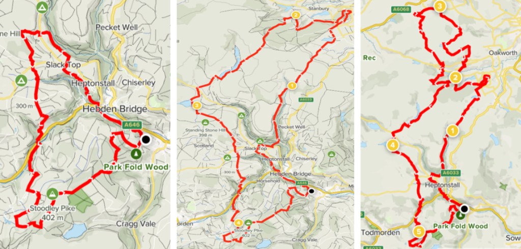
There will be three races: a 25km, 50km, and 75km. Race headquarters will be at the Stubb Playing Fields, Mytholmroyd (grid reference SE 00636 25993), which will also be the start and finish location for all races.
We are expecting approximately 200 runners for the 25km event, 200 runners for the 50km event, and 100 runners for the 75km event. There will also be approximately 30 crew members in attendance, including directing staff, safety staff, an experienced expedition medical team, an osteopathy team, and a team of volunteers.
All three of the races’ head West from Race HQ through Hebden Bridge and towards Slack Top along the Rochdale Canal Path. At the top of Colden Road, at the 5km point, the routes separate with the 50km/75km courses heading East along the Calder Aire Link towards Penistone Hill Country Park and the 25km route continuing East to loop around Stoodley Pike before returning to Race HQ.
From Penistone Hill Country Park the 50km route will turn and loop back following the Bronte Way and the Pennine Bridleway to connect with the Half Marathon course near Colden. The 75km route will continue along the Pennine Way towards Cowling before turning Southeast towards Oldfield to rejoin the 50km course at the Ponden Reservoir and continue onwards as above.
There will be six checkpoints/aid stations on the route (six for the 75km route, four for 50km route and one for the 25km), where runners will be able to refuel with food and water. The checkpoints will be situated at grid references SD 99553 32410, SD 99828 36722, SD 98520 42589, SD 94666 31253 and SD 96806 24171.
The full routes (including proposed checkpoint locations) can be viewed online here. These may be subject to minor alterations in the lead up to the event which will be communicated to stakeholders as appropriate.
All races will be run on public rights of way (predominantly the Pennine Way), and other permissive paths with prior permission granted from landowners.
Runners will be required to cross the A646 at grid references SD 98867 27203 and SD 96807 26087, Slack Road at grid reference SD 97795 28677, Moorside Lane at grid references SE 01851 36105 and SE 01791 36281, Badgers Lane at grid reference SD 96752 27457. We will have fluorescent “Caution Runners in Road” and “Crossing Point” signs on the approach to these crossing points to warn vehicle traffic, runners, and other road users.
The routes will be marked using a combination of small red flags (staked into the ground on either side of the trail), ribbons (tied to trees, branches, fence posts etc), and laminated signs (cable tied to lampposts, fences etc) depending on terrain. All signage will be labelled to identify each item as belonging to our organisation and all markings will be removed within 24 hours of the end of the event.
Copies of additional information can be seen via the links set out below.
I would welcome any comments or advice regarding any oversight relating to these documents.
If you have any queries regarding this event, please don’t hesitate to contact me,
Regards,
Seb Moulding
Ultra X Summer Trails Series Race Director
Email seb@ultra-x.co Phone 07837 787784
